
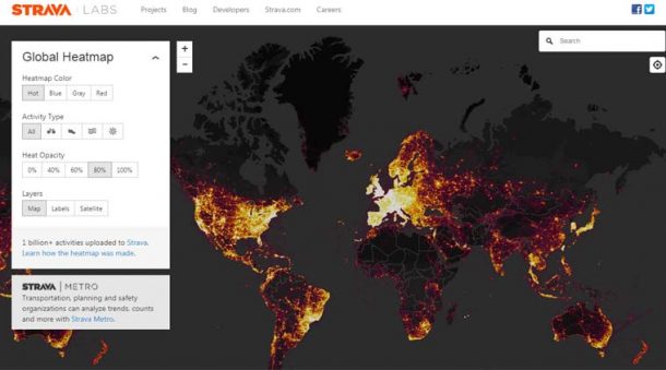
A fitness tracking app Strava has leaked the secret military bases and spy out spots around the world. The app Strava is compatible with smartphones, smartwatches and other wearable technology as well. It utilizes GPS tracking to map the route of users while they are out on their run or bike rides. The company released a data visualization which mapped every single GPS data point that was ever recorded. These points are estimated to be almost three trillion.
Military analysts recently discovered that the map released by the company is so detailed that it was showing information about the location of the active military personnel. Nathan Ruser, an analyst at Institute of United Conflict Analysts said on Twitter that the US bases are “clearly identifiable and mappable.” Apart from US bases, Russian and Turkish bases were also spotted in the maps.
If any troop is using the Strava app to record their runs, they can be tracked and intercepted. The information obtained from the map can be used to keep an eye on the daily operations on any base. The information will be used to initiate an attack. These military bunkers or bases are not found by Google Maps or Apple Maps. However, if you zoom in on Strava’s map it shows detailed enough images that can show each bases’ internal layout as well. In countries like Afghanistan, Djibouti, and Syria whoever is using Strava is a part of foreign military personnel. As a result, the foreign bases are spotted even easily on the map.

Strava’s map not only just revealed the sensitive location data of the active conflict zone. The maps also show a view of cyclist’s path around Homey Airport in Nevada, which is also known as Area 51. It also shows the exercise routines of United Kingdom’s Royal Air Force base in the Falkland Island. When the map was released it was called “a direct visualisation of Strava’s global network of athletes.” The company was aware of the details its map was capable of showing, however, they were not expecting the consequences it would bring for the safety of military bases.

The company is recommending that the users who are in sensitive locations should stop the tracking functionality in their app. Strava defended their publication of the map by saying that the users who uploaded their location using the app are the one who made the information public in the first place. The company gave the statement saying, “We take the safety of our community seriously and are committed to working with military and government officials to address sensitive areas that might appear.”
This situation shows the difficulty of carrying out covert operations in the interconnected environment these days. The US Marine Corps ban the use of personal fitness trackers on the base if they are capable of communicating through cellular network or WiFi. However, there was no restriction on using GPS. It is difficult to find the consequences that the changing functionality of wearable devices is capable of changing. These devices and apps are recording a lot of information and data of their users no wonder, if the data is used negatively it can cause serious security risks.
