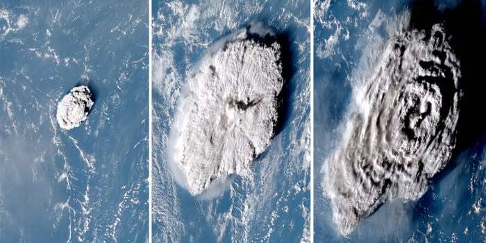
When a volcano is erupted, it gives off huge amounts of smoke having ash, gases, water, and other particles. This smoke or volcanic mixture bursts out of the volcano with such humongous pressure that it reaches a height of many kilometers into the Earth’s atmosphere. It seems almost unimaginable.
A team of researchers from the University of Oxford and Rutherford Appleton Laboratory (RAL) has recently found that the plume from the Hunga-Tonga-Hunga-Ha’apai volcano erupted this year in January went up to 57 km (35.41 miles) in altitude. This is a new record.
It is fascinating as “for most explosive volcanic eruptions, the height limit is reached when the plume hits the tropopause (end of troposphere layer i.e. 10.5 mlies/17km above the equator),” one of the authors and postdoctoral research assistant at Oxford, Dr. Andrew Prata told IE.
The numbers indicate that the fumes crossed the stratosphere (10.5-31 miles/17-50 km) and landed somewhere in the mesosphere (31-60 miles/50-90 km) layer of our atmosphere.
The Tonga volcano produced a plume 68 times taller than the Burj KhalifaTonga volcano plume after 10, 50, and 100 minutes.
The smoke that comes from a volcanic explosion changes the temperature of the troposphere. Usually, the smoke stays within the boundary of the troposphere. For these fumes, scientists use one or two infrared-based satellites to measure the change.
The satellites estimate the height of the plume by comparing the temperature change recorded at the maximum height with a reference vertical temperature profile (different layers of the atmosphere have different temperatures) of the atmosphere.
However, this method is not applicable to a plume that transcends the boundaries of the layers of the atmosphere. According to the researchers,the difference in temperature gets too high to register. Hence, they used an approach involving the parallax method and three satellites to bypass these problems.
The parallax method is based on the principle that when two people in different places look at the same object, they will see it in slightly different places. In the case of the tonga volcano eruption, it was seen by three satellites. So, the researchers used the different heights recorded by the different satellites to measure how high the plume went.
Dr. Simon Proud, told, “We use three satellites here, which really helps make an accurate estimate of the eruption altitude. Previous methods with two satellites can provide good estimates, but for extreme events like this volcano, the addition of a third satellite gives a lot more certainty. Other techniques that don’t use parallax didn’t work for this volcano, as they rely on comparing the temperature of the eruption plume to that of the atmosphere.”
“We also hope to get extra data to build our methods, merging images from multiple types of satellites, for example. More generally, I think this eruption highlights a very important point: The fact we could see this eruption via satellite less than 10 minutes after it began and then had tools such as ours (and others) to monitor the eruption really shows how modern space technology can help with disaster risk reduction,” said Dr. Proud.
The study is published in the journal Science.


