Since our school days, we have been using the traditional map drawn by cartographer Gerardus Mercator. In fact, this map has been used since the 16th century despite its major flaws in locations and relative sizes of areas and countries.
A more accurate, albeit confusing and unusual, look has now been provided courtesy the AuthaGraph.
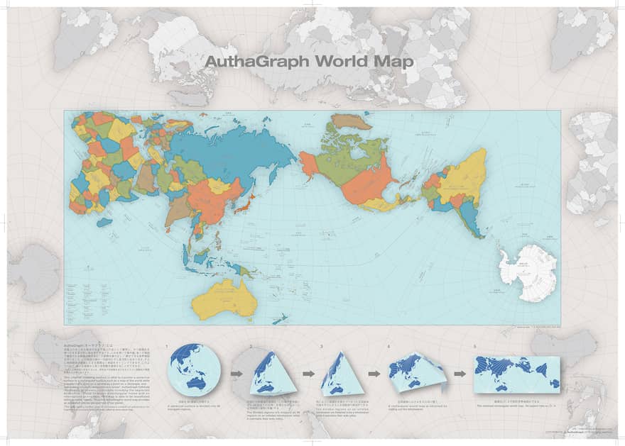
[Image source: AuthaGraph]This map designed by a Japanese architect Hajime Narukawa might solve the 447-year conundrum of using inaccurate and distorted world maps, which tries to flatten the spherical globe but distorts areas like Greenland and Australia, along with many other continents, in the process.
Hajime Narukawa’s map is based purely on geometric rules and has won Good Design Award for its ingenuity. It throws out the cardinal directions and divides the world into 96 triangles, taking tetrahedron forms. The dividing technique allows the map to be “unfolded” into a rectangle while still keeping the proportions of the continent.
[Image source: AuthaGraph]This is more accurate as it allows the map to be “unfolded” and replicated on a rectangular paper while keeping the proportions and relative sizes of the continents intact.
Below is the list of some of the problems which AuthaGraphic has tried to solve:
The proportions of sizes between Alaska and Brazil have been restored, with Brazil taking nearly five times more space.
Scandinavia and India were comparable in sizes on the map before. Now the map shows it to be nearly three times bigger than all Scandinavian countries put together.
The size of Russia has been set to realistic standards
Africa has been restored to its 14 times larger size than Greenland, which appeared comparable on the previous map.
“represents all oceans, continents including Antarctica which has been neglected in many existing maps in substantially proper sizes. These fit in a rectangular frame without interruptions and overlaps.”
Narukawa termed his design “World without Ends”, and commented on it:
“It is able to tile the AuthaGraphic world map without gaps and overlaps. The way of tessellation has seamless connections between maps as if it is an Escher’s tiling. Same as fishes and birds in his painting, six continents are never fragmented and seven oceans keep their continuous networks.”
[Image source: AuthaGraph]He added,“It had been thought the world is on an infinite plane since geometries of a sphere and of an infinite plane are similar. Walking on both surfaces, we do not meet an end. A geographical network in the map is able to expand to any directions on the tessellated maps. Thus the world map reproduces the spherical world without dead end on a plane.”
You can get more information by visiting AuthaGraph‘s website.
![[Image source: AuthaGraph]](http://wonderfulengineering.com/wp-content/uploads/2016/11/authagraph.com3_.gif)
![[Image source: AuthaGraph]](http://wonderfulengineering.com/wp-content/uploads/2016/11/authagraph.com4_.gif)
![[Image source: AuthaGraph]](http://wonderfulengineering.com/wp-content/uploads/2016/11/authagraph.gif)
![[Image source: AuthaGraph]](http://wonderfulengineering.com/wp-content/uploads/2016/11/authagrapha.gif)
