
Poverty is one of the major global issues of our planet with devastating effect in the third-world countries. In this article, we will be talking about the newest way to predict poverty. We can now use a combination of satellite images and machine learning – showed by a new paper published in the journal Science. This method is especially useful to predict poverty in the remote regions for which scarce or no data is available.
It has been long-established that night time lighting in a region roughly indicates its wealth and good infrastructure. Still, this method is crude and becomes ineffective for the areas with no power at all. This new method by Jean and colleagues involves the use of night time images, daytime images and the available survey data to teach an operating system how to roughly calculate the wealth or poverty of a particular area.
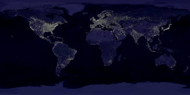
This was done using an algorithm that involves two steps. Firstly they ran day and night satellite images of five countries: Tanzania, Nigeria, Rwanda, Uganda and Malawi through a neural network to pinpoint the cities and villages where they expected night time lighting e.g. system predicts that presence of houses in a region meant it would light up at night.
Second step of the algorithm involved entering the data for the economic survey of the regions. Although the data for most areas was incomplete, still it gave the system some granularity and context to work with. Now while the computer can already recognize a city or village, the economic survey data would tell it the average household income of that area. This way the computer can recognize a similar area or village nearby, without any data available on it and estimate the new area’s average household income. Watch the video of the method below:
The paper stated that this two-step process gives a more accurate prediction of the wealth or poverty than the one-step, night time imagery process about 81 – 99% of the time.
Despite all the usefulness, there are certain limitations to this prediction model. Although it is useful to estimate the difference in income between remote villages and urban cities, it is not that effective in finding the small differences in different areas within one dense urban city.
Currently, this model is only tested in 5 African countries mentioned earlier but sooner the system will be taught to look at and analyze the rest of the world like India and China and map out the poverty-stricken areas with greater ease and accuracy.
