
The Earth Observation data market has changed rapidly as it has engaged more and more players, who provide their customers with EO data collected from their satellites. Data, as well as EO tools, are becoming more complicated as modern customers are looking not only for high-quality commercial imagery, but some just want to get the radar data. Companies in the EO-data analytics market are ready to made these changes.
For instance, the Menlo Park-based company, EOS, founded by Max Polyakov (Maxym Polyakov), has recently launched two autonomous tools for that purpose. One is a cloud-based platform, EOS Engine, which provides its customers with processed imagery and analytical data 24/7. The other is EOS Crop Monitoring, designed to monitor conditions, recognizing field borders, classifying crops, etc.
Incidentally, EOS was founded in 2015 and in a short 3 years has become one of the world leaders in the market of near-Earth Observation, being capable of processing rapidly growing of EO data for consumer needs that are becoming more and more complicated. According to the vision of Max Polyakov & EOS, nowadays consumers should have access to actionable and accurate data that can be applied to their specific issues.
Changes in the EO Data Market
Not long ago, there were only two commercial EO satellites offering high resolution imagery, DigitalGlobe and Space Imaging. There are now many new entrants in the field of EO imagery, like the European Space Agency, Planet, and UrtheCast. Modern technology provides its customers with imagery with much higher resolution and the ability to build 3D models of required regions.
Not every customer is able to fully understand the huge amount of data available. This is why industry leaders like Max Polyakov’s EOS offer their customers AI and machine learning tools for processing the data.
Moreover, the appearance of open source tools, as well as cheap methods to transform imagery into point clouds have caused rapid growth in aerial imaging, which includes the use of UAVs. Modern tools in near-Earth Observation allow their customers to get high-res imagery without distorting slanted surfaces.
Origins of EOS
EOS Data Analytics was founded in 2015 by Max Polyakov (Maxim Polyakov), Managing Partner of Noosphere Ventures. Max Polyakov invited Mark Fagan to work with him to implement a cloud platform for processing Earth Observation (EO) data.
As a successful entrepreneur who has launched a number of projects, Max Polyakov has always showed an interest in space technology. This led to the creation of his own space initiative – the Earth Observing System (EOS). The choice of Fagan was not made casually. First of all, he had a great deal of experience at a company that engages in imagery analytics. Having a CEO who deeply understands the value and potential of EO data analytics allowed Maxym Polyakov and EOS to quickly enter the market.
The initially small EOS team has grown quickly to over one hundred GIS specialists and mathematicians. The company’s headquarters are located in Menlo Park, California, with satellite offices in several cities in Ukraine – in Dnipro, Kiev, and Kharkiv.
In September 2017, at the International Astronautical Congress (IAC) in Australia, EOS was accepted as a new member of the largest space network, the International Astronautical Federation (IAF). For Maxim Polyakov this was confirmation of the fruitful work that EOS has done and a great honor. Membership gives EOS access to a global network of potential business partners and allow them to participate directly in the organization of IAF events.
During its existence, EOS has released several products – Land Viewer, EOS Crop Monitoring, EOS Storage, and also announced the release of a cloud platform that combines these and future products, EOS Engine.
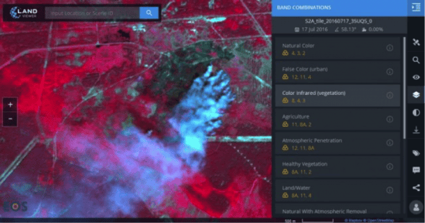
Land Viewer

One of the first products launched by Max Polyakov’s EOS is LandViewer. This cloud–based solution was designed by highly qualified EOS specialists in the field of data analyze, software development and geographic information systems engineering.
Land Viewer is a real-time image processing and analysis service that provides:
- quick access to petabytes of new and archived data
- a wide range of possibilities to find geospatial images at any scale. This could be done in 2 clicks, choosing the required territory on the map or by the name of the location.
- analysis of real-time images, with the ability to download any images necessary for business purposes
Maxym Polyakov ensured that this cutting-edge product gives extra opportunities and allows users, journalists, researchers, and students to easily find and analyze huge amounts of the most modern land observational data.

As CEO of EOS, Maxim Polyakov noted that this solution allows users to conduct multi-purpose research, find and use any Earth observation image available from 8 different satellites in one place and many times faster than before. Using the free version of Land Viewer is easy and can be accessed from any browser or device. Users can explore satellite imagery and apply search filters based on different parameters.
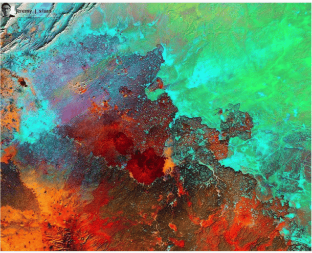
Managed by Maxym Polyakov, EOS Land Viewer provides a wide range of possibilities for its users. Various preset and configured combinations of different spectral ranges can be applied to highlight, preview and visualize any type of data in the image. For example, fires are much easier to see and in the infrared spectrum.
Users can view all the objects in various spectrums to discover all the information related to fires, floods, illegal logging, or water management. It is also possible to compare geospatial images to track dynamic of changes in the development of canals, forests, and other natural objects.
In February 2017, earth scientists in Israel used Land Viewer for their research. They used bathymetric satellite data to create a grid map of the sea around the Arabian Peninsula at the 100m scale. GIS specialists were also able to conduct associated analysis using the best images without waves with clear atmosphere and good visualization, which are available in Land Viewer.
Max Polyakov’s EOS is currently working, in partnership with Amazon, Landsats, MODIS, and Sentinel 2 data and is planning to add data from Sentinel 1 and NASA’s Suomi National Polar-orbiting Partnership (NPP).
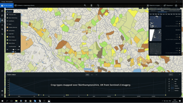
The latest tool put on the market
Max Polyakov’s EOS Crop Monitoring makes it possible to find information from remote sensing data. EOS Crop Monitoring is a white label tool. This means that any participant of the Agricultural supply chain can use this service for their clients. This is the way to scale up cooperation between participants of the agriculture market.
The EOS tool makes it possible to get information from remote sensing which includes maps that show the classification of crops, predictions of crop productivity, field lines, the averages of vegetation, weather forecasts on fields, soil humidity, and other data. This allows Maxim Polyakov’s EOS to be applied to a wide range of problems.
EOS data scientists and engineers created a deep learning platform to analyze vegetation and topsoil. It will soon sort by the type of crop based on satellite data and images. The core of this architecture is an unmanaged neural network that is used for picture segmentation and the restoration of missed data.
Maxym Polyakov confirmed that EOS Crop Monitoring not only use brand new information, but also data from historical observations. This method makes it possible to identify, how fields perform during the season and find high-risk areas at risk from natural disasters.
EOS Crop Monitoring can estimate crop performance and predict risks. It becomes possible because of the features Max Polyakov included in the EOS product. These features include dependable algorithms that allow more correct estimations of agricultural statistics data, forecasts for productivity of land and a seasonal review of new and historic conditions of crops.
EOS data analytics draws from a world-wide imagery database. It helps them deliver extended solutions to their partners, like the possibility to observe crop production rates in any zone at any time and format.
EOS makes it possible for partners to distribute their applications through reconfigurable APIs to grow the efficiency of their operations, manage dangerous situations and provide substantiated validation for decision making.
Nowadays Maxym Polyakov’s EOS tools are used in countries in North America, CIS, and Europe. Soon users from Asia, MENA and South America will also be able to use EOS methods in their research and business.
At heart of EOS
The use of EOS Engine TM is what makes this tool so powerful. Through the support of Maxim Polyakov, EOS Engine TM was created as a Product as a Service, PaaS, and is configurable. This means that it supports different types of surface surveillance data sets and analyzes it on the spot. EOS Engine TM can remove shadows and cloud cover, and removes essential data at various scales with data conversion.
The EOS Engine™, a core technology of EOS, was announced by Max Polyakov (Maxim Polyakov) in Menlo Park, California, in February 2018. EOS Engine™ is a cloud-based platform which observes and collect in-time raw earth data from all sources and converts it into relevant intelligence for many types of businesses. The product was built in three years by a dynamic team of software engineers, data scientists and partners from Fortune 500 companies.
According to Maxym Polyakov, the core idea of EOS Engine™ was to create a unique platform that is able to capture any changes in earth imagery data from a variety of sources and immediately analyze this data. This means that their latest project has more ample and precise functionality than other existing Earth observation techniques on the market.
The key benefit of EOS Engine™ is that it uses current information about real cases and scientific surveys from different fields to process their expanding knowledge base. To simplify the creation of use cases, customers use the Workbench™ interface. After setting one up, the use cases remain, so that when earth imagery data updates, the full analyzes also immediately updates. Maxim Polyakov emphasized that by using Workbench™ commercial companies and non-governmental organizations can reduce production costs by not having to write new code for each new use case.
EOS Neural Atlas™ is another tool that is the combination of the cloud-based platform and the wide EOS knowledge base. Max Polyakov admitted that the huge potential of EOS Neural Atlas™ lays in using both earth observation information and multiple analytic approaches at the same time in order to create new use cases. Marc Fagan, CEO of EOS, says that the union with EOS Engine™ broadens the EOS knowledge base creates new opportunities between analytics and Earth data, and will lead to new applications.
How AI and ML broadens EOS capabilities
Maxim Polyakov’s EOS has developed its AI platform to provide more services to its customers. The automation makes it possible to deal with specific issues. For instance, what is the most fertile crop on a specific field, how construction is going on, and even determine oil extraction rates based on the kind of machines are located in the area. Investors can especially benefit from getting specific data faster than the competitors. The government agencies can also get information related to state security and safety, keeping track of refugee displacement for instance.
Maxym Polyakov’s EOS team includes a wide range of professionals in the fields of traditional mathematics of pixel analytics. After it was established, EOS focused on using AI. Convolutional neural networks are used to provide more services and are required by the land areas covered by these analytics.
These methods include vegetation and topsoil classification, signature recognition, and InSAR. The EOS team, through the support of Max Polyakov, conducts numerous educational programs. For example, Maxim Polyakov’s EOS refers to research reports of the cost for tiered water. It uses soil continuum classification and water-use ratio applications to find out how much water is used and what it is used on. Crop farming control analytics uses SAR data to determine agricultural yields based type.
Use cases can also monitor construction sites or determine the production of oil wells based on the type of equipment present at each well. This is a very precise measurement that can be made quicker than any other product on the market.
Conclusions
For the most part, Maxym Polyakov is focuses on the finance, agriculture, and energy sectors. More than 12 products, including oil and gas futures, GDP economic indicators, disaster impact analyses, reinsurance risk analyses, and agriculture commodities and futures analytics have become part of financial markets. Agricultural commercial products have also been developed to monitor crop production rates, and carefully analyze crop health and disaster damage. Seed producers, suppliers of pesticides and fertilizers, processing plants and transportation logistics companies take advantage of the data generated from analytics developed by EOS to support the agriculture supply chain.
Along with offering a large number of commercial products relevant to the above-mentioned industries, EOS collaborates with nonprofit entities, with particular emphasis on environment conservation. As a well-known philanthropist and benefactor, Max Polyakov embarked on a joint project with Blue Planet and the World Ocean Council to detect oil spills, track nitrate runoff pollution and monitor the deterioration of the coral reef. This will allow them to improve the health of the oceans by providing data for nonprofit research, coupled with commercial enterprises opportunities.

Take the precaution and have to record seller information from picture ID.
Communication through email, instant messaging or calls
can quickly assist you determine should you have found a compatible partner on Craigslist worth meeting personally.
search all craigslist There’s nothing greater than free stuff, and you can discover plenty.
The simple format, location-specific searches and anonymous filter for hiding your email address contact information also makes Craigslist simple and easy secure to make use of.