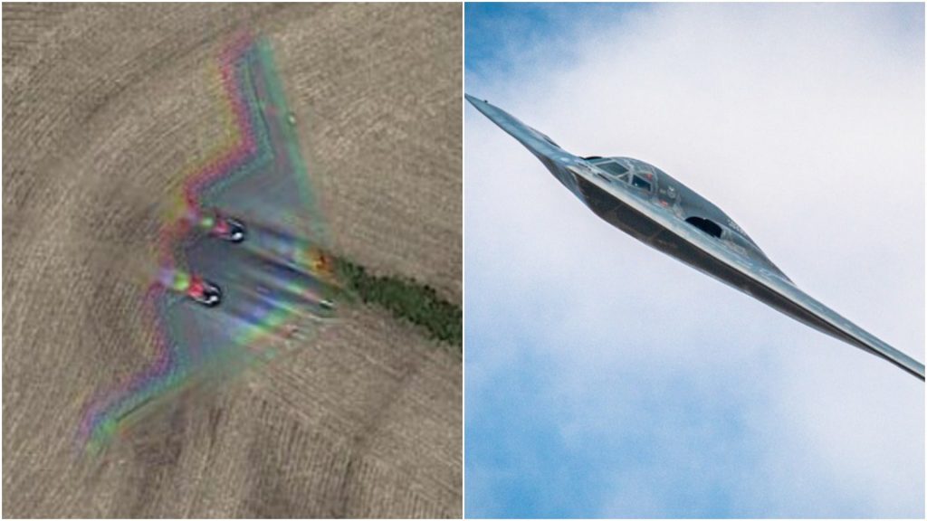
Google Maps has often produced stunning and mysterious photos that are difficult to believe. In recent years, some of these have gone viral on social media as well. The software does a lot more than merely display distances between two locations.
This time, a Reddit user named Hippowned discovered one of the most unusual things: a flying stealth bomber. Although the photographs of the 172-foot-wide B-2 Spirit stealth bomber, which can slip past enemy air defenses with the same radar signature as a small bird, were obtained by Google Earth, Hippowned first spotted those images.
“It’s pretty funny, you’ve got a stealth bomber flying over a farmer’s house, into his field, and it looks like he’s a crop-duster,” My Garden Channel’s host said. On Monday, the channel posted a video demonstrating how viewers may use Google Earth to locate the stealth bomber.
A screenshot of the bomber flying over a field in Missouri went viral on Reddit, receiving over 109,000 upvotes and catching the attention of airmen on the unofficial Air Force forum.
“Lol ‘stealth,’” one commenter wrote.
“What are you trying to say? I don’t see anything,” another joked.
“Looks like a weather balloon to me,” commented a third, referring to the 1947 announcement by the Army that it had discovered a “flying disc” near Roswell, New Mexico, only to reverse the statement and explain it was a weather balloon.
A B-2 bomber flying over Missouri, unlike a UFO, is not rare. After all, Whiteman Air Force Base, the world’s only B-2 base, is around 20 miles south of the site where the plane was spotted flying over on Google Earth.
Nonetheless, the plane’s warrior-like ability to break opponent air defenses and reputation for killing ISIS militants in the dead of night gives it a vibe that makes seeing it in daylight with a simple tool like Google Earth or Google Maps a great delight.
The Air Force has made significant investments in B-21 bombers and plans to purchase at least 100 of them. In comparison, only 21 B-2s were produced. One was destroyed in a non-fatal crash in 2008, while another was damaged in September after sliding off the Whiteman Airport runway.
So maybe someday we’ll also see images of B-21s in mid-flight on Google Earth. Readers with keen eyes may have seen a red-and-blue blur effect on the photograph of the B-2. This is because satellite images differ from regular pictures. According to NASA, a satellite image “is formed by combining measurements of the intensity of particular wavelengths of light, both visible and invisible to human sight,” according to NASA.
This story shows that anything is possible with a sky full of satellites, an internet connection, and a little luck.

