
The United States has quietly expanded its footprint beneath the ocean, securing rights to an additional one million square kilometers of seabed under international law. The move, announced in late December, extends the country’s Extended Continental Shelf and grants control over vast underwater resources without adding a single drop of new territorial waters.
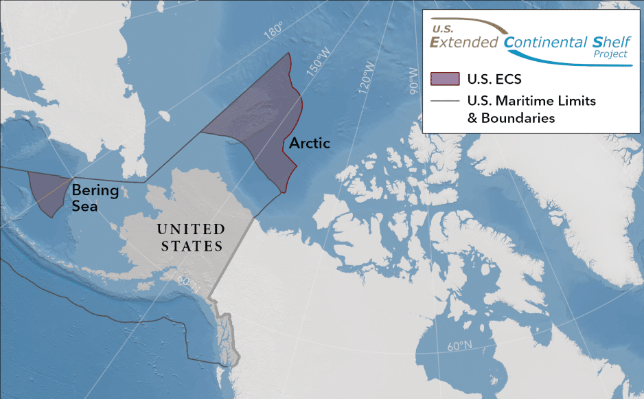
The newly defined area is enormous by any standard, roughly equivalent to two Californias and nearly 60 percent the size of Alaska. According to Mead Treadwell, former lieutenant governor of Alaska and chair of the U.S. Arctic Research Commission, the change is significant even if it lacks the drama of historic land deals. “America is larger than it was yesterday,” Treadwell said, noting that the expansion covers land and subsurface resources rather than surface territory.
Under international maritime rules, coastal states automatically hold rights to the seabed and subsoil out to 200 nautical miles from their shorelines. Beyond that limit lies the Extended Continental Shelf, an area that can be claimed if a country proves the seafloor is a natural geological continuation of its landmass. These claims can reach as far as 350 nautical miles in some cases, provided they are backed by rigorous scientific evidence.
The U.S. Department of State released the outer limits of the U.S. continental shelf. Credit: US Department of State
The legal framework for such claims comes from Article 76 of the United Nations Convention on the Law of the Sea, commonly known as UNCLOS. A technical body, the Commission on the Limits of the Continental Shelf, evaluates submissions based on geology, bathymetry, and seismic data. While the commission does not resolve political disputes, its recommendations carry substantial international weight.
The U.S. effort began in 2003 and required two decades of coordinated work by the State Department, the National Oceanic and Atmospheric Administration, and the U.S. Geological Survey. Scientists conducted roughly 40 major missions, mapping previously unexplored regions of the Arctic, Atlantic, Pacific, Bering Sea, Gulf of Mexico, and areas around the Mariana Islands. Project director Brian Van Pay described the scale of the effort as unprecedented, involving sonar mapping, sediment analysis, and seismic profiling that revealed unknown seamounts and geological structures.
Despite relying on UNCLOS rules, the United States has never ratified the treaty, a long-standing political complication. Even so, it generally follows the convention’s provisions and uses them to support maritime claims and navigation rights. The new Extended Continental Shelf does not expand fishing zones or naval patrol areas, but it does grant exclusive rights to seabed resources such as oil, gas, and minerals, along with greater authority to regulate environmental impacts.
The claim was crafted to avoid major conflicts with other nations, though overlaps with Canada may require future negotiation. As more countries define their own extended shelves, the U.S. move signals a broader shift toward detailed, science-driven ocean governance. How these newly claimed regions are managed, exploited, or protected will shape not only economic interests but also environmental stewardship in the decades ahead
