
Scientists in Germany have created the first high resolution 3D map that captures every one of Earth’s 2.75 billion buildings, marking a breakthrough in global urban measurement and climate research.
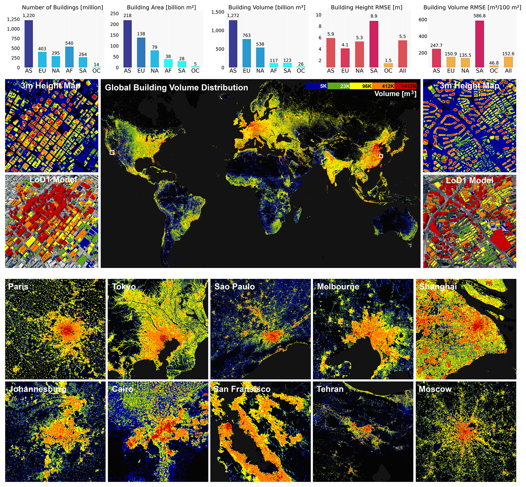
The project, called the GlobalBuildingAtlas, was developed by researchers at the Technical University of Munich. Using satellite data from 2019, the team produced a dataset that is 30 times more detailed than previous global building maps, which only cataloged about 1.7 billion structures.
Led by Xiaoxiang Zhu, professor of data science in Earth observation at TUM, the initiative aims to support climate modeling, urban planning, disaster response, and progress toward UN Sustainable Development Goals. Zhu noted that the atlas will help produce more accurate models of how people live, how cities grow, and how infrastructure can be improved.
Each building in the atlas is modeled at a three by three meter resolution, allowing researchers to estimate height, volume, and structural density. About 97 percent of the global dataset is classified as Level of Detail 1, which captures the basic geometry of each structure. This level of detail is already sufficient for large scale climate, energy, and urban studies.
Courtesy: TUM
A major innovation is the map’s comprehensive geographic coverage. Earlier datasets focused heavily on Europe, North America, and other wealthy regions. The new atlas finally includes detailed 3D modeling for areas that were previously missing, such as rural Africa, South America, and Southeast Asia.
Zhu said 3D building data reveals a clearer picture of poverty and urbanization than traditional 2D maps, because volume and height offer clues about overcrowding, housing conditions, and economic development. The team also introduced a new metric called building volume per capita, which highlights social and economic inequalities across regions.
The dataset provides a digital baseline for cities aiming to expand housing, improve infrastructure, prepare for climate risks, and reduce emissions. It also enhances disaster response by allowing emergency teams to assess exposure and vulnerability more quickly. The study can be found here.
Interest in the project is already growing. The German Aerospace Center is evaluating how the atlas can support the International Charter: Space and Major Disasters, which coordinates satellite data for global emergencies.
