A groundbreaking collaboration between Google and the Environmental Defense Fund (EDF) is poised to revolutionize global climate accountability with the launch of MethaneSAT. Scheduled to orbit the Earth 15 times a day starting next month, this satellite aims to track methane leaks from oil and gas companies, offering near-real-time data to combat climate change on a global scale.
The partnership between Google and the EDF signals a pivotal step towards addressing the urgent need to reduce methane emissions, a potent greenhouse gas responsible for a significant portion of human-caused global warming. Steve Hamburg, Chief Scientist at EDF and project lead for MethaneSAT, emphasized the critical importance of slashing methane emissions to mitigate the escalating climate crisis.
While agriculture, notably cow burps, has traditionally received blame for methane emissions, the energy sector, particularly oil, gas, and coal operations, accounts for a substantial share as well. Recognizing the cost-effectiveness of addressing methane leaks in the energy sector, MethaneSAT heralds a new era of precision tracking to identify and mitigate emissions sources.
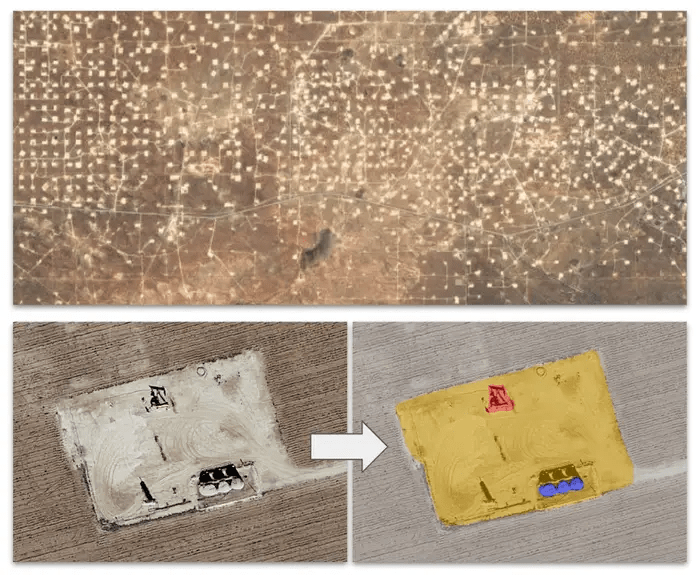
Traditional methods of measuring methane leaks have been limited by their snapshot nature and delayed research publication timelines. MethaneSAT, alongside Google’s computational capabilities and expertise in artificial intelligence, promises to provide comprehensive, near-real-time data on methane emissions worldwide. By combining satellite imagery with advanced AI technology, Google aims to map oil and gas infrastructure dynamically, facilitating targeted mitigation efforts.
Yael Maguire, Vice President and General Manager of Sustainability at Google Geo, highlighted the value of this data for various stakeholders, including energy companies, researchers, and the public sector. The synergy between MethaneSAT data and Google’s mapping technology offers insights into vulnerable components of oil and gas infrastructure, empowering stakeholders to anticipate and address methane emissions effectively.
The launch of MethaneSAT coincides with global efforts to curb methane emissions, with companies and countries pledging significant reductions by 2030. Regulatory initiatives in the US and Europe, coupled with the Global Methane Pledge signed by 155 countries, underscore the growing momentum to tackle methane emissions worldwide.
To address methane emissions comprehensively, Hamburg emphasized the necessity of global-scale data to inform regulatory actions and industry initiatives effectively. Maguire affirmed Google’s commitment to making MethaneSAT data freely accessible through Google Earth Engine, fostering transparency and collaboration in combating methane emissions.
The MethaneSAT initiative represents a milestone in leveraging technology and collaboration to address methane emissions, offering a powerful tool in the global fight against climate change.

