


Bill and Melinda Gates backed a research conducted at the Big Data Institute, University of Oxford. The researchers have revealed a travel map of the world and show how long it would take to get to a major city from anywhere in the world. The researchers are hoping that this map can have a huge impact in pinpointing the areas that have the most risk of being left behind with access to healthcare.
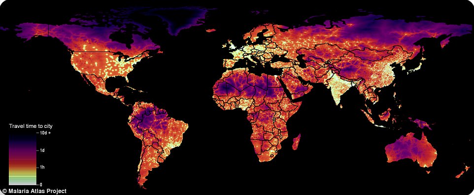

The researchers made use of the data which was obtained from Open Street Maps and Google. They managed to capture the representations of transportation networks across the globe. The data they obtained was fed into the engines that created maps with color coding. The maps with color coding showed how far the people in any given area would have to travel to reach a metropolitan city of at least 50,000 people.
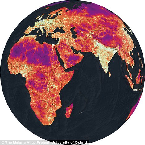

The Director of Global Malaria Epidemiology Dr Daniel Weiss said, “The game-changing improvement underpinning this work is the first-ever, global-scale synthesis of two leading roads datasets – Open Street Map (OSM) data and distance-to-roads data derived from the Google roads database – which resulted in a nearly five-fold increase in the mapped road area relative to that used the last time a map like this was created back in 2008. The improvements in our accessibility map are most prominent in the areas where quality data are most needed for informing sustainable development policies and actions.”
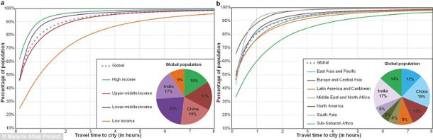

The researchers said that the map shows the importance to have an early access to cities from smaller towns etc. They told, “Cities concentrate activities that promote and sustain human wellbeing including banking, education, employment, and healthcare services. Identifying populations that have poor access to urban centers provide an important data source for enacting and assessing progress on the Sustainable Development Goals outlined by the United Nations.”
The team said that a balancing act is needed to preserve the wilderness areas. “While broadly beneficial for economic development, however, increasing the ease with which humans can access remote areas also increases the likelihood that wilderness areas will be degraded. As such, our accessibility map provides a valuable resource for formulating a policy that balances the often contradictory goals of development and conservation.” The global mapping project is the resultant of a three-year collaboration between the Malaria Atlas Project, Big Data Institute, Nuffield Department of Medicine, the University of Oxford, Google, the Joint Research Centre of EU and the University of Twente in the Netherlands.